
MEMBERS & VISITORS
Distorted Perceptions and Geopolitics
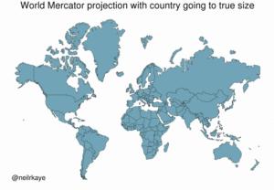
This Clever Map Shows the True Size of Countries
MAPS: Distorted Perceptions and Geopolitics
In a more globally connected world, geographic literacy is more important than ever. As young African students see distorted views of non African lands they develop misconceptions about the size of continents and their respective nations. This will become a thing of the past when schools in all nations teach the truth. Mercator’s map pumps up the sizes of Europe and North America. Visually speaking, Canada and Russia appear to take up approximately 25% of the Earth’s surface when in reality they occupy a mere 5%. Malcolm X aptly stated that many modern super powers are masters of “tricknology”.
With 3D Globe Mode on Google Maps desktop, Greenland’s projection is no longer the size of Africa. In the analog world, simply show children a round globe then let their perform their own discoveries of truth. This will sidestep map projection issues and the resultant harmful brainwashing which accompanies it.
Mechanical/Solar Engineer, Prof. Oku Singer
(43)